I love Las Vegas, but not for
all the reasons most people love Las Vegas. Surrounded by amazing places to climb and run, a 30 to 45 minute
drive in any direction can have you hiking Lava Fields, climbing up red rocks, running
in a bowl of “fire”, checking out views above Lake Mead, peak bagging desert
mountains, or laboring at high altitude. It’s that last option that always
seems to call to me. NW of famous Red Rock canyon is an amazing “sky Island” of snow-capped
peaks and epic adventures. Charleston Peak,
the 8th most prominent mountain in the U.S., tops out at 11,918 feet
and gets all the attention but the Spring mountains have nine summits that break
10,000 feet with class 1 & 2 trails as well as some seriously technical
climbing available. Always cooler than the scorching desert below, the area can
hold snow well into May. When MURCA announced a 2nd annual MURCA
V50K with a time frame that happened to line up with a planned business trip to
Sin City, I knew right away where my V50K would be!
MURCA, or the Marine Ultra Runners
Club of America is an awesome group started by a motivated Marine named Mike
Harris. MURCA is populated with bad ass Marines and former Marines who all
share a love of the long run. I mean…really bad ass. These gyrenes have laminated
bad ass cards. If I start to get cocky about the epic shit I do, all it takes
is five minutes reading posts on the MURCA page and I’m back down to earth. More than a Facebook group, MURCAns across the country (and around the world,
actually) reach out and support each other, it’s tangible. It’s a positive and motivating
environment and I've found that it provides me with the connection
to Marines that I'd been missing since leaving active duty nine years ago. The group also has amazing fundraising efforts
for Veteran causes. The 2019MURCA Virtual 50K was held to benefit The Warriors Keep. So, now that you
have some background and a little context, here is my V50K run report…
The original plan was to
repeat a route I had soloed in November of 2017. I would run the North loop trail bagging Fletcher
Peak, Mummy Mountain, Charleston Peak, Griffith Peak, and Cathedral Rock while
descending on the South loop trail. In 2017 it was snow free and bone dry with
only a little bit of ice on each summit and I was able to knock it out in eight
hours. It was one of my most epic days in the mountains and I was thrilled at
the chance to do it again on March 25th! However, the closer to departure
day it got, the more evident it became that the route wasn’t going to be feasible.
The 2018-19 winter had seen a record amount
of snow fall on the spring mountains and snow storms were still occurring as
late as the week before I flew in. Most of the trail heads above 8,000 feet were
inaccessible. Avalanche danger was extremely high and the south loop trail would
require a couple of hours in a notorious avalanche chute. With heavy snow, the
north loop approach below Charleston's summit becomes a severely exposed 60-70 degree snow slope that
requires crampons and an Ice Axe. Being on a business trip, I wasn’t planning
on packing that kind of gear and frankly, I wanted the V50K to be a run…not a 12-hour deep snow & technical
climb. About five days out I came up with a back-up plan. Hayford Peak in the
Sheep range north of Vegas should be snow free and close to where I’d be
staying. Not quite as epic but run-able and, more importantly, it offered less
chance of getting “avalanched”. Still, I
held out a little hope that once I got there, I could find a doable route in the
Spring Mountains.
 |
| Spring Mountains a month before the trip. Looking Epic! |
My plane hit Vegas at 9am on
March 24th and from the small round window it was easy to spot the
Spring mountains. So much for the little hope; “My god, so much snow…it looks
like Nanga Parbat!”. I grabbed a rental car and made my way north, resigned to
scout out the approach to Hayford peak across the
Desert National Wildlife Refuge (DNWR) from my beloved Spring Mountains. Or so
I thought…when I hit DNWR, it became clear that the little rental sedan was not
going to get me anywhere near the trail head. I didn’t have a plan C and was
feeling a little dejected. Since I was staying at the Mount Charleston resort,
I decided I’d go ahead and make my way to the Spring mountains and scout out
some trails to run for fun the next day. Assuming that the V50K was off, I
would simply enjoy being in the mountains and could just come up with a V50K route
back home in May or June.
At this point things started
to really fall in place. I hit the North loop trail head and ran six miles in
my Kahtoola’s. Hmmm, it would be slow going in the snow but it looked like
Charleston’s little sister, Fletcher Peak, could be do-able. It wouldn’t be
anywhere near 50K distance from the NL trail head. However, driving back down
Deer Creek Road to the resort, I happened to spot a trail coming out of the woods
with no markings or trail head. It was about two miles down from the North loop
trail head and looked to head South East away from the mountains. Chatting with
the locals at the resort I learned there are MTB trails all over the SE side of
the Spring mountains that extend all the way down to below 5,000 ft. In fact,
the trail I had spotted was called either “tin can alley” or “cowboy” according
to the Resort’s cartoon trail map. Theoretically, I could start down in the desert
around 5,000 feet and connect the various MTB trails to deer creek road, run
the two miles up the road to the NL trail head, bag Fletcher Peak and retrace
my steps! I’d be short of a 50K but could refuel and do a shorter out-n-back to
make it up. Now equipped with a plan C and feeling tired from the flight, the time
zone change, and the altitude adjustment; I put my gear together, set the alarm
for 0500, and crashed.
Deciding to forego my usual
alpine start since I’d be navigating a spiderweb of unknown MTB trails, I woke
a little before dawn. Some toast, honey, and an apple later I was in the rental
car heading back down Kyle Canyon road to a trail head near the Harris Springs
road turnoff. A cold morning, it was hovering in the low 30’s as the first sliver
of sun hit the desert. Looking SE, I could make out the dark outline of La
Madre Mountain. To the West were the snowy Spring Mountains and my destination.
Looking up I could see an impressive planetarium of stars beginning to fade. Just
a perfect morning. I crossed Kyle Canyon road and hit the first MTB trail.
The first few miles were pretty
uneventful as I tried to get into an easy slow rhythm to wake up the legs. Going
out too fast was not a problem as I could already feel the uphill tack. Starting
at just over 5,000 ft, I would be going up all morning to a 10,500 foot summit
so I made sure to put in some hiking breaks early to save my legs. Did I say
uneventful? There’s just no such thing in the Mountains. Every direction I
looked provided a fantastic view. Around mile three the eastern edge of the
Spring Mountains came into full view and I knew there’d be no speed records
today. Forget the snow and altitude gain slowing me down, I was going to have
to stop often to take pictures!
 |
| Moving from the desert to the Spring mountains. To the left is Kyle Canyon. |
A little after three miles I
veered north away from Kyle Canyon Road as the terrain changed significantly
from high desert to mountain foothills. At Mile 4 or 5 I hit the first snow. Much
deeper at 6,000 ft than expected, I walked right over the top of it without
snow shoes since it was still early enough to be frozen pretty solid. Navigating
the MTB trails became a little tougher since the trail was invisible beneath
the snow. At mile 5 the trail moved closer to deer creek road and my map showed
that it basically ran parallel with the road for a few miles. Nevertheless, I
was pretty relieved when the trail spit me out onto the road at the unmarked
point I had seen yesterday. “Damn, I just might pull this route off” I said to
the road kill in front of me. It was then two miles up the hardball to the
North Loop TH.
At around 8,000 ft., the North
Loop trail head became “crampon point” as I strapped on the Kahtoola’s and took
in some calories. The temperature had increased so I knew there would be some post
holing before the day was over. I set off at a decent pace for Fletcher Peak. Route finding became very difficult as there
really was no trail to see with all of the snow. I tried to follow the map by
imagining the terrain snow-free. I also had to slow down since my feet started
to punch through for some intermittent post-holing.
 |
| Sign near "crampon point". |
Around mile 10 at 9,400 feet
or so, I was underneath a big snow slope that was just glittering in the sun. It
was awesome but my internal alarm was starting to tingle. I just didn’t like
the angle of the slope, the amount of snow up towards what I could see of the top
of the slope, and the weirdly angled tree tops sticking out below me from an
earlier-in-the-season avalanche that had obviously occurred. I decided to
follow my tracks back out of the slope. According to my map, it looked like I
had veered off of the North loop trail and was underneath Bristlecone Peak (Officially
UN 10,089). Not wanting to risk the slope to get to the Fletcher approach I
made the decision to go for Bristlecone’s summit instead.
After backtracking out of the
slope I started up the North ridge of Bristlecone. Sooo much snow. It became
really deep and soft. Post-holing for about 300 feet, I was moving slowly but sweating
my ass off. At the same time, my right toes were really aching from the cold. Back
in 2011 I had suffered some serious frostbite on my right big toe during a50 mile winter night race and ever since, my right foot has been a little
sensitive. A few weeks before this trip I had gotten mild frostbite again on
that toe running through ice water at the Psycho Wyco 50K. I just kept wiggling
my toes and tried to keep moving as fast as I could (which was not very fast).
Finally, there was nothing
above me and I was on the summit of Bristlecone Peak! Looking back east was
Angel Peak and the desert beyond where I could even see Hayford Peak way out on
the horizon. To the south was Fletcher Peak. I could see mummy mountain right
across from me to the NW. Just to the west of Fletcher across Kyle Canyon was Harris
Mountain and Griffith Peak. I had an outstanding view of the ridge line from
Griffith Peak to Charleston Peak and lost myself for a moment in the memory of running
that ridge in 2017. What an amazing place! I felt blessed to be standing there
and so grateful that I had managed to find a do-able route in the Spring mountains
after all.
The Nuwuvi, whose traditional
lands included the Spring Mountains consider thesemountains sacred as their place of creation. Standing there, I understood
this and thought of words from Anatoli Boukreev:
“Mountains
are not stadiums where I satisfy my ambitions to achieve. They are cathedrals,
grand and pure, the houses of my religion. I approach them as any human goes to
worship. On their altars I strive to perfect myself physically and spiritually.
In their presence I attempt to understand my life, to exorcise vanity, greed,
and fear. From the vantage of their lofty summits, I view my past, dream of the
future, and with unusual acuteness I experience the present moment. That
struggle renews my strength and clears my vision. In the mountains I celebrate
creation, for on each journey I am reborn"
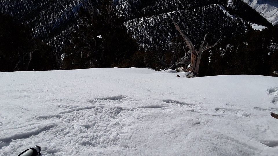
 |
| Bristlecone tree on the Summit of Bristlecone Peak. The Charleston ridge in the background with Griffith Peak to the left. |
OK, it was time to wake up
and get moving again as I was only at mile 10 or 11 and had a long day ahead of
me. Looking over the SE side of Bristlecone’s long summit, it looked like I had
made the right call earlier in the day as the steepness of the slope was even
more apparent from up here. I would now simply have to follow my tracks back
down, sliding down my earlier post-holes was a little taxing. Once out of
post-hole country, I was able to really let it loose and bomb back down the trail
making up some time riding my summit “high”. Other than moving a little too fast, the run
back down to the MTB trail head was pretty uneventful…but very scenic.
At mile 20.3 I was back at
the car. After changing my t-shirt and refilling water and gels, I set off for
another loop, this time planning to stay below 7,300 feet. At mile 22.5, I took
a side trail up Telephone canyon moving through some thick brush and trees. Well into the day, it was getting pretty warm
in this canyon and there were unmapped side trails everywhere making navigation
a little tough. I basically followed a dry creek bed until it met up with a
trail called “showgirl” on my map. At that point I was back in the snow when
the trail turned southwest to link up with a trail I’d been on earlier in the day.
During this second loop my
eyes kept getting drawn to this small peak that looked really rocky (and snow
free). My 2nd loop was basically a big oval surrounding the peak that
according to the map, was UN 7,401. Finding what looked to be an unofficial
small trail at around 7,300 feet, I decided to go for it and within a few
minutes I was on the top of my second summit of the day at mile 26.5. Feeling
really knackered, I only spent a couple of minutes on the summit before moving
back down the unmarked trail. I linked back up to the “cowboy” trail and tried
to run back to the trail head. Miles 27 – 30 should have been very run-able as
it was all downhill, but I was feeling as knackered as I’ve ever been on a 50K.
I managed to get a little trot going and made it back to the car at 30.9 miles
with a time of 8:29:00. Not exactly the day I’d planned several months before
but sometimes that’s for the best. An awesome challenge in creating my route on
the fly and given the conditions, I was so happy to have been able to pull off
a 50K and a couple of summits in the Spring Mountains. Just a great day. I will
always jump at the chance for a trip to Vegas, I just may not spend much time in Vegas!
Huge thank-you to Mike Harris
and MURCA for coming up with such a cool concept for an event. The first two
V50k events were just a blast and I look forward to many more. I love
self-supported ultras in the wilderness. Awesome event and awesome cause. Thank-you
to the Prairie Band Potawatomi Nation, I am honored to be their Health Center
Director and grateful that they often send me to mountainous places for business
and allow me the time to run and climb while there. And always, special thanks
and love to Jessica, Alyena, Ayden, & Tristyn. You guys are with me on
every mile of every run!


No comments:
Post a Comment